
Wyndham City
Suburbs and localities that form part of the Wyndham City municipality in south-west Melbourne include Cocoroc, Hoppers Crossing, Laverton, Laverton North, Little River, Mambourin, Manor Lakes, Point Cook, Quandong, Tarneit, Truganina, Werribee, Werribee South, Williams Landing and Wyndham Vale.
Background
Following the launch of the Metlink brand across Melbourne in 2004, pocket-sized guides with multi-modal network maps were distributed to households around Melbourne. 31 different editions are available, one for each municipality. The maps often include suburbs adjoining municipal boundaries.
Each map is drawn by the experts at Melway. The original versions had all bus services colour-coded orange, which made it difficult to read for areas with numerous overlapping bus services, such as Manningham or Greater Dandenong. These were reissued again in June 2005, correcting various errors in the original versions.
 In September 2007 the first maps were sighted in a new full-colour format, making the bus network much easier to decipher. These maps would gradually appear for most municipalities over the next couple of years, with the map for Mornington Peninsula Shire finally coming online in April 2011. PTV have continued to issue these maps since the April 2012 rebrand.
These maps effectively superseded the former fold-out Melbourne-wide Public Transport Map, however printed editions have not been issued since 2011, other than in brochures for major network changes. A new-style printed format has since been seen for the “Melbourne By Bus” marketing campaign.
Below we have uploaded various editions issued for City of Wyndham, however we stress this is not a complete set by any means. Where possible, we have noted the reason(s) for the updated map.
Prior to the introduction of the Wyndham Local Area Map by Metlink, an earlier network map was included in a Werribee area timetable booklet issued by Westrans Werribee.
Later Metlink timetable booklets also included schematic/diagrammatic network maps for both Werribee and Point Cook.
We have also included links to these maps.
Maps
Westrans Werribee Network Map (Kefford)- November 2002 (PDF)
- Introduction of Route 444 Tarneit Loop (initially anti-clockwise only)
Westrans Werribee Network Map (Kefford) – February 2006 (PDF)
- Extension of Route 438 in Wyndham Vale
- Revision of Route 442 in The Grange estate
- Route 444 Tarneit Loop now made bi-directional and extended via Baden Powell Dr and Rose Grange Bvd in Tarneit
- Introduction of limited-stops Route 445 serving Thames Bvd, Tarneit (incorrectly shown as 435)
Wyndham City – April 2010 (PDF)
- Route 416 extended along Boardwalk Blvd in Point Cook
- New Route 417 from Laverton to Laverton North Industrial areas
- Route 442 extended from The Grange to Hummingbird Bvd in Tarneit
- Route 438 and parts of Route 440 deleted in Wyndham Vale and replaced by new Routes 447, 448 & 449, with new coverage into Manor Lakes
- New Route 443 (Weribee – South Ring Road) – started 19 April 2010 – new route provides a simplified two way service to the South Ring Rd area
- New Route 446 (Laverton – Hoppers Crossing via Werribee) replacing parts of Route 440 and introduced service along Sayers Road
Wyndham City – May 2011 (PDF)
- Revised Route 442 in The Grange to serve Virgilia Dr, restoring previous coverage
- Route 448 extended from Werribee Plaza to Hoppers Crossing Station (with no stopping restrictions on Heaths Rd, unlike Routes 413 & 445)
- Route 446 now travels along Westmeadows La in Truganina
- Route 449 now operates via Wyndham Vale Square Shopping Centre
Wyndham City – November 2011 (PDF)
- Route 413 truncated at Hoppers Crossing Station, no longer running to Werribee Plaza
- Route 415 now operates directly to Laverton via Alma Ave, losing its loop via Central Square Shopping Centre and Aircraft Shops
- Route 416 now operates from Laverton via Central Square Shopping Centre and Central Ave
Wyndham City – April 2013 (PDF)
- Opening of Williams Landing Station
- Point Cook Routes 413 & 416 replaced by new Routes 493, 494, 495, 496 & 497
- Eastern end of Route 446 rerouted from Laverton to Williams Landing
- NightRider Route 944 sets-down at Williams Landing Station upon request
Wyndham City – July 2014 (PDF)
- New Werribee Plaza interchange opened 14 April 2014
- Route 439 rerouted past Wyndham Harbour and some of the market gardens coverage removed
- Route 445 stopping restrictions removed along Heaths Rd and Tarneit Rd
- Route 454 in Sunshine West replaced by Routes 427 & 428
Wyndham City – June 2015 (PDF)
- Regional Rail Link opens with Geelong trains now serving new stations at Wyndham Vale and Tarneit (instead of Werribee)
- New bus network in the triangle between Wyndham Vale, Tarniet, Werribee and Hoppers Crossing
- New ‘connector’ routes include 150, 160, 170, 180, 190 & 192
- New local routes include 153, 161, 166, 167, 181 & 191
- Routes 417 & 496 extended to Aircraft Shops interpeak and weekends (496)
- Route 443 South Werribee Loop streamlined
- Route 493 deleted and replaced by new 153 & 498 and revised Route 495
- Route 496 extended into Sanctuary Lakes estate and Aircraft off-peak
- New Route 498 route providing new east-west route on Syndes Rd plus additional frequency in Seabrook. Trips on Route 498 through-route into Route 181, reinstating a one-seat ride from Point Cook to Werribee Plaza.
Wyndham City – January 2016 (PDF)
- NightRider Route 944 replaced by Night Bus 944, truncated at Point Cook rather than Werribee
- New Night Bus 945 to Wyndham Vale providing new overnight coverage to Brooklyn, Laverton North, Truganina & Tarneit
Wyndham City – August 2017 (PDF)
- Route 191 extended from Manor Lakes to Jubilee Estate
- Route 441 extended from Westleigh Gardens Estate to Riverwalk Estate
- Route 497 extended 1km east in Saltwater Coast Estate
Wyndham City – May 2021 (PDF)
- New Route 152 Tarneit to Williams Landing via Leakes Rd
- New Route 182 Tarneit to Werribee via Davis Rd
Wyndham City – September 2021 (PDF)
- Route 944 & 945 Night Buses deleted
- Night Bus hours introduced on Routes 150, 180 & 190
- New 949 Night Bus Loop from Williams Landing via Point Cook South & Altona Meadows
Wyndham City – October 2022 (PDF)
- Tarneit North FlexiRide introduced
Wyndham City – November 2023 (PDF)
- Tarneit Station interchange relocated to southern side for all routes except FlexiRide
Wyndham City – August 2024 (PDF)
- Minor relocation for 494 & 495 Point Cook South terminus
Wyndham City – July 2025
- Significant frequency and span upgrades on Routes 170, 180, 190 & 192
- No new Local Area Map issued
Wyndham City – December 2025 (PDF)
- New Route 154 from Tarneit to Laverton via Truganina North
- New Route 194 from Wyndham Vale Station to Harpley via Mambourin
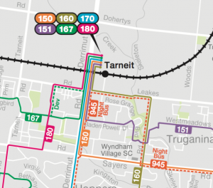
- Routes 150, 151, 167 & 170 return to northern interchange at Tarneit Station (with stop opposite Tarneit Central Shopping Centre reinstated)
- Major frequency & span upgrades to Route 153 to serve new Wyndham Court precinct and Hoppers ‘golden mile’ along Old Geelong Rd